A | B | C | D | E | F | G | H | CH | I | J | K | L | M | N | O | P | Q | R | S | T | U | V | W | X | Y | Z | 0 | 1 | 2 | 3 | 4 | 5 | 6 | 7 | 8 | 9
Republic of Colombia | |
|---|---|
| Motto: "Libertad y Orden" (Spanish) ("Freedom and Order") | |
| Anthem: Himno Nacional de la República de Colombia (Spanish) ("National Anthem of the Republic of Colombia") | |
.svg) Location of Colombia (dark green) | |
| Capital and largest city | Bogotá 4°35′N 74°4′W / 4.583°N 74.067°W |
| Official languages | Spanish |
| Recognized regional languages | English (in San Andrés and Providencia) 64 other languages |
| Ethnic groups |
|
| Religion (2022)[3] |
|
| Demonym(s) | Colombian |
| Government | Unitary presidential republic |
| Gustavo Petro | |
| Francia Márquez | |
| Legislature | Congress |
| Senate | |
| Chamber of Representatives | |
| Independence from Spain | |
• Declared | 20 July 1810 |
• Recognized | 7 August 1819 |
• Last unitarisation | 1886 |
• Secession of Panama | 1903 |
| 4 July 1991 | |
| Area | |
• Total | 1,141,748 km2 (440,831 sq mi) (25th) |
• Water (%) | 2.1 (as of 2015)[4] |
| Population | |
• 2023 estimate | 49,336,454[5] (29th) |
• Density | 42.23/km2 (109.4/sq mi) (173rd) |
| GDP (PPP) | 2023 estimate |
• Total | |
• Per capita | |
| GDP (nominal) | 2023 estimate |
• Total | |
• Per capita | |
| Gini (2020) | high |
| HDI (2021) | high · 88th |
| Currency | Colombian peso (COP) |
| Time zone | UTC−5 (COT) |
| Date format | dd-mm-yyyy (CE) |
| Driving side | right |
| Calling code | +57 |
| ISO 3166 code | CO |
| Internet TLD | .co |
| |


Colombia (/kəˈlʌmbiə/ (![]() listen), /-ˈlɒm-/;[13] Spanish: (
listen), /-ˈlɒm-/;[13] Spanish: (![]() listen)), officially the Republic of Colombia,[a] is a country mostly in South America with insular regions in North America. The Colombian mainland is bordered by the Caribbean Sea to the north, Venezuela to the east and northeast, Brazil to the southeast, Ecuador and Peru to the south and southwest, the Pacific Ocean to the west, and Panama to the northwest. Colombia is divided into 32 departments. The Capital District of Bogotá is also the country's largest city hosting the main financial and cultural hub, and other major urbes include Medellín, Cali, Barranquilla, Cartagena, Santa Marta, Cúcuta, Ibagué, Villavicencio and Bucaramanga. It covers an area of 1,141,748 square kilometers (440,831 sq mi), and has a population of around 52 million. Colombia is the largest Spanish-speaking country in South America. Its cultural heritage[14]—including language, religion, cuisine, and art—reflects its history as a colony, fusing cultural elements brought by mass immigration from Europe[15][16][17][18] and the Middle East,[19][20][21] with those brought by the African diaspora,[22] as well as with those of the various Indigenous civilizations that predate colonization.[23] Spanish is the official language, although English and 64 other languages are recognized regionally.
listen)), officially the Republic of Colombia,[a] is a country mostly in South America with insular regions in North America. The Colombian mainland is bordered by the Caribbean Sea to the north, Venezuela to the east and northeast, Brazil to the southeast, Ecuador and Peru to the south and southwest, the Pacific Ocean to the west, and Panama to the northwest. Colombia is divided into 32 departments. The Capital District of Bogotá is also the country's largest city hosting the main financial and cultural hub, and other major urbes include Medellín, Cali, Barranquilla, Cartagena, Santa Marta, Cúcuta, Ibagué, Villavicencio and Bucaramanga. It covers an area of 1,141,748 square kilometers (440,831 sq mi), and has a population of around 52 million. Colombia is the largest Spanish-speaking country in South America. Its cultural heritage[14]—including language, religion, cuisine, and art—reflects its history as a colony, fusing cultural elements brought by mass immigration from Europe[15][16][17][18] and the Middle East,[19][20][21] with those brought by the African diaspora,[22] as well as with those of the various Indigenous civilizations that predate colonization.[23] Spanish is the official language, although English and 64 other languages are recognized regionally.
Colombia has been home to many indigenous peoples and cultures since at least 12,000 BCE. The Spanish first landed in La Guajira in 1499, and by the mid-16th century they had colonized much of present-day Colombia, and established the New Kingdom of Granada, with Santa Fé de Bogotá as its capital. Independence from the Spanish Empire was achieved in 1819, with what is now Colombia emerging as the United Provinces of New Granada. The new polity experimented with federalism as the Granadine Confederation (1858) and then the United States of Colombia (1863), before becoming a republic—the current Republic of Colombia—in 1886. With the backing of the United States and France, Panama seceded from Colombia in 1903, resulting in Colombia's present borders. Beginning in the 1960s, the country has suffered from an asymmetric low-intensity armed conflict and political violence, both of which escalated in the 1990s. Since 2005, there has been significant improvement in security, stability and rule of law, as well as unprecedented economic growth and development.[24][25] Colombia is recognized for its health system, being the best healthcare in the Americas according to The World Health Organization and 22nd on the planet,[26][27] In 2022, 26 Colombian hospitals were among the 61 best in Latin America (42% total).[28] Also in 2023, two Colombian hospitals were among the Top 75 of the world.[29][30]
Colombia is one of the world's seventeen megadiverse countries; it has the third-highest level of biodiversity in the world.[31] Its territory encompasses Amazon rainforest, highlands, grasslands and deserts. It is the only country in South America with coastlines (and islands) along both the Atlantic and Pacific oceans. Colombia is a key member of major global and regional organizations including the UN, the WTO, the OECD, the OAS, the Pacific Alliance and the Andean Community; it is also a NATO Global Partner.[32] Its diversified economy is the third-largest in South America, with macroeconomic stability and favorable long-term growth prospects.[33][34]
Etymology
The name "Colombia" is derived from the last name of the Italian navigator Christopher Columbus (Latin: Christophorus Columbus, Italian: Cristoforo Colombo, Spanish: Cristóbal Colón). It was conceived as a reference to all of the New World.[35] The name was later adopted by the Republic of Colombia of 1819, formed from the territories of the old Viceroyalty of New Granada (modern-day Colombia, Panama, Venezuela, Ecuador, and northwest Brazil).[36]
When Venezuela, Ecuador, and Cundinamarca came to exist as independent states, the former Department of Cundinamarca adopted the name "Republic of New Granada". New Granada officially changed its name in 1858 to the Granadine Confederation. In 1863 the name was again changed, this time to United States of Colombia, before finally adopting its present name – the Republic of Colombia – in 1886.[36]
To refer to this country, the Colombian government uses the terms Colombia and República de Colombia.[37]
History
Pre-Columbian era

Owing to its location, the present territory of Colombia was a corridor of early human civilization from Mesoamerica and the Caribbean to the Andes and Amazon basin. The oldest archaeological finds are from the Pubenza and El Totumo sites in the Magdalena Valley 100 kilometers (62 mi) southwest of Bogotá.[38] These sites date from the Paleoindian period (18,000–8000 BCE). At Puerto Hormiga and other sites, traces from the Archaic Period (~8000–2000 BCE) have been found. Vestiges indicate that there was also early occupation in the regions of El Abra and Tequendama in Cundinamarca. The oldest pottery discovered in the Americas, found at San Jacinto, dates to 5000–4000 BCE.[39]
Indigenous people inhabited the territory that is now Colombia by 12,500 BCE. Nomadic hunter-gatherer tribes at the El Abra, Tibitó and Tequendama sites near present-day Bogotá traded with one another and with other cultures from the Magdalena River Valley.[40] A site including eight miles (13 km) of pictographs that is under study at Serranía de la Lindosa was revealed in November 2020.[41] Their age is suggested as being 12,500 years old (c. 10,480 B.C.) by the anthropologists working on the site because of extinct fauna depicted. That would have been during the earliest known human occupation of the area now known as Colombia.[citation needed]
Between 5000 and 1000 BCE, hunter-gatherer tribes transitioned to agrarian societies; fixed settlements were established, and pottery appeared. Beginning in the 1st millennium BCE, groups of Amerindians including the Muisca, Zenú, Quimbaya, and Tairona developed the political system of cacicazgos with a pyramidal structure of power headed by caciques. The Muisca inhabited mainly the area of what is now the Departments of Boyacá and Cundinamarca high plateau (Altiplano Cundiboyacense) where they formed the Muisca Confederation. They farmed maize, potato, quinoa, and cotton, and traded gold, emeralds, blankets, ceramic handicrafts, coca and especially rock salt with neighboring nations. The Tairona inhabited northern Colombia in the isolated mountain range of Sierra Nevada de Santa Marta.[42] The Quimbaya inhabited regions of the Cauca River Valley between the Western and Central Ranges of the Colombian Andes.[43] Most of the Amerindians practiced agriculture and the social structure of each indigenous community was different. Some groups of indigenous people such as the Caribs lived in a state of permanent war, but others had less bellicose attitudes.[44]
Colonial period
_-_An%C3%B3nimo.jpg)
Alonso de Ojeda (who had sailed with Columbus) reached the Guajira Peninsula in 1499.[45][46] Spanish explorers, led by Rodrigo de Bastidas, made the first exploration of the Caribbean coast in 1500.[47] Christopher Columbus navigated near the Caribbean in 1502.[48] In 1508, Vasco Núñez de Balboa accompanied an expedition to the territory through the region of Gulf of Urabá and they founded the town of Santa María la Antigua del Darién in 1510, the first stable settlement on the continent. [Note 2][49] Santa Marta was founded in 1525,[50] and Cartagena in 1533.[51] Spanish conquistador Gonzalo Jiménez de Quesada led an expedition to the interior in April 1536, and christened the districts through which he passed "New Kingdom of Granada". In August 1538, he founded provisionally its capital near the Muisca cacicazgo of Muyquytá, and named it "Santa Fe". The name soon acquired a suffix and was called Santa Fe de Bogotá.[52][53] Two other notable journeys by early conquistadors to the interior took place in the same period. Sebastián de Belalcázar, conqueror of Quito, traveled north and founded Cali, in 1536, and Popayán, in 1537;[54] from 1536 to 1539, German conquistador Nikolaus Federmann crossed the Llanos Orientales and went over the Cordillera Oriental in a search for El Dorado, the "city of gold".[55][56] The legend and the gold would play a pivotal role in luring the Spanish and other Europeans to New Granada during the 16th and 17th centuries.[57]
The conquistadors made frequent alliances with the enemies of different indigenous communities. Indigenous allies were crucial to conquest, as well as to creating and maintaining empire.[58] Indigenous peoples in New Granada experienced a decline in population due to conquest as well as Eurasian diseases, such as smallpox, to which they had no immunity.[59][60] Regarding the land as deserted, the Spanish Crown sold properties to all persons interested in colonized territories, creating large farms and possession of mines.[61][62][63] In the 16th century, the nautical science in Spain reached a great development thanks to numerous scientific figures of the Casa de Contratación and nautical science was an essential pillar of the Iberian expansion.[64] In 1542, the region of New Granada, along with all other Spanish possessions in South America, became part of the Viceroyalty of Peru, with its capital in Lima.[65] In 1547, New Granada became a separate captaincy-general within the viceroyalty, with its capital at Santa Fe de Bogota.[66] In 1549, the Royal Audiencia was created by a royal decree, and New Granada was ruled by the Royal Audience of Santa Fe de Bogotá, which at that time comprised the provinces of Santa Marta, Rio de San Juan, Popayán, Guayana and Cartagena.[67] But important decisions were taken from the colony to Spain by the Council of the Indies.[68][69]

In the 16th century, European slave traders had begun to bring enslaved Africans to the Americas. Spain was the only European power that did not establish factories in Africa to purchase slaves; the Spanish Empire instead relied on the asiento system, awarding merchants from other European nations the license to trade enslaved peoples to their overseas territories.[71][72] This system brought Africans to Colombia, although many spoke out against the institution.[Note 3][Note 4] The indigenous peoples could not be enslaved because they were legally subjects of the Spanish Crown.[77] To protect the indigenous peoples, several forms of land ownership and regulation were established by the Spanish colonial authorities: resguardos, encomiendas and haciendas.[61][62][63]
However, secret anti-Spanish discontentment was already brewing for Colombians since Spain prohibited direct trade between the Viceroyalty of Peru, which included Colombia, and the Viceroyalty of New Spain, which included the Philippines, the source of Asian products like silk and porcelain which was in demand in the Americas. Illegal trade between Peruvians, Filipinos, and Mexicans continued in secret, as smuggled Asian goods ended up in Córdoba, Colombia, the distribution center for illegal Asian imports, due to the collusion between these peoples against the authorities in Spain. They settled and traded with each other while disobeying the forced Spanish monopoly.[78]
.svg)
The Viceroyalty of New Granada was established in 1717, then temporarily removed, and then re-established in 1739. Its capital was Santa Fé de Bogotá. This Viceroyalty included some other provinces of northwestern South America that had previously been under the jurisdiction of the Viceroyalties of New Spain or Peru and correspond mainly to today's Venezuela, Ecuador, and Panama. So, Bogotá became one of the principal administrative centers of the Spanish possessions in the New World, along with Lima and Mexico City, though it remained somewhat backward compared to those two cities in several economic and logistical ways.[79][80]
Great Britain declared war on Spain in 1739, and the city of Cartagena quickly became a top target for the British. A massive British expeditionary force was dispatched to capture the city, but after initial inroads devastating outbreaks of disease crippled their numbers and the British were forced to withdraw. The battle became one of Spain's most decisive victories in the conflict, and secured Spanish dominance in the Caribbean until the Seven Years' War.[70][81] The 18th-century priest, botanist and mathematician José Celestino Mutis was delegated by Viceroy Antonio Caballero y Góngora to conduct an inventory of the nature of New Granada. Started in 1783, this became known as the Royal Botanical Expedition to New Granada. It classified plants and wildlife, and founded the first astronomical observatory in the city of Santa Fe de Bogotá.[82] In July 1801 the Prussian scientist Alexander von Humboldt reached Santa Fe de Bogotá where he met with Mutis. In addition, historical figures in the process of independence in New Granada emerged from the expedition as the astronomer Francisco José de Caldas, the scientist Francisco Antonio Zea, the zoologist Jorge Tadeo Lozano and the painter Salvador Rizo.[83][84]
Independence


Since the beginning of the periods of conquest and colonization, there were several rebel movements against Spanish rule, but most were either crushed or remained too weak to change the overall situation. The last one that sought outright independence from Spain sprang up around 1810 and culminated in the Colombian Declaration of Independence, issued on 20 July 1810, the day that is now celebrated as the nation's Independence Day.[85] This movement followed the independence of St. Domingue (present-day Haiti) in 1804, which provided some support to an eventual leader of this rebellion: Simón Bolívar. Francisco de Paula Santander also would play a decisive role.[86][87][88]
A movement was initiated by Antonio Nariño, who opposed Spanish centralism and led the opposition against the Viceroyalty.[89] Cartagena became independent in November 1811.[90] In 1811, the United Provinces of New Granada were proclaimed, headed by Camilo Torres Tenorio.[91][92] The emergence of two distinct ideological currents among the patriots (federalism and centralism) gave rise to a period of instability.[93] Shortly after the Napoleonic Wars ended, Ferdinand VII, recently restored to the throne in Spain, unexpectedly decided to send military forces to retake most of northern South America. The viceroyalty was restored under the command of Juan Sámano, whose regime punished those who participated in the patriotic movements, ignoring the political nuances of the juntas.[94] The retribution stoked renewed rebellion, which, combined with a weakened Spain, made possible a successful rebellion led by the Venezuelan-born Simón Bolívar, who finally proclaimed independence in 1819.[95][96] The pro-Spanish resistance was defeated in 1822 in the present territory of Colombia and in 1823 in Venezuela.[97][98][99]
The territory of the Viceroyalty of New Granada became the Republic of Colombia, organized as a union of the current territories of Colombia, Panama, Ecuador, Venezuela, parts of Guyana and Brazil and north of Marañón River.[100] The Congress of Cúcuta in 1821 adopted a constitution for the new Republic.[101][102] Simón Bolívar became the first President of Colombia, and Francisco de Paula Santander was made Vice President.[103] However, the new republic was unstable and the Gran Colombia ultimately collapsed.
Modern Colombia comes from one of the countries that emerged after the dissolution of Gran Colombia, the other two being Ecuador and Venezuela.[104][105][106] Colombia was the first constitutional government in South America,[107] and the Liberal and Conservative parties, founded in 1848 and 1849, respectively, are two of the oldest surviving political parties in the Americas.[108] Slavery was abolished in the country in 1851.[109][110]
Internal political and territorial divisions led to the dissolution of Gran Colombia in 1830.[104][105] The so-called "Department of Cundinamarca" adopted the name "New Granada", which it kept until 1858 when it became the "Confederación Granadina" (Granadine Confederation). After a two-year civil war in 1863, the "United States of Colombia" was created, lasting until 1886, when the country finally became known as the Republic of Colombia.[107][111] Internal divisions remained between the bipartisan political forces, occasionally igniting very bloody civil wars, the most significant being the Thousand Days' War (1899–1902).[112]
20th century
The United States of America's intentions to influence the area (especially the Panama Canal construction and control)[113] led to the separation of the Department of Panama in 1903 and the establishment of it as a nation.[114] The United States paid Colombia $25,000,000 in 1921, seven years after completion of the canal, for redress of President Roosevelt's role in the creation of Panama, and Colombia recognized Panama under the terms of the Thomson–Urrutia Treaty.[115] Colombia and Peru went to war because of territory disputes far in the Amazon basin. The war ended with a peace deal brokered by the League of Nations. The League finally awarded the disputed area to Colombia in June 1934.[116]

Soon after, Colombia achieved some degree of political stability, which was interrupted by a bloody conflict that took place between the late 1940s and the early 1950s, a period known as La Violencia ("The Violence"). Its cause was mainly mounting tensions between the two leading political parties, which subsequently ignited after the assassination of the Liberal presidential candidate Jorge Eliécer Gaitán on 9 April 1948.[117][118] The ensuing riots in Bogotá, known as El Bogotazo, spread throughout the country and claimed the lives of at least 180,000 Colombians.[119]
Colombia entered the Korean War when Laureano Gómez was elected president. It was the only Latin American country to join the war in a direct military role as an ally of the United States. Particularly important was the resistance of the Colombian troops at Old Baldy.[120]
The violence between the two political parties decreased first when Gustavo Rojas deposed the President of Colombia in a coup d'état and negotiated with the guerrillas, and then under the military junta of General Gabriel París.[121][122]

After Rojas' deposition, the Colombian Conservative Party and Colombian Liberal Party agreed to create the National Front, a coalition that would jointly govern the country. Under the deal, the presidency would alternate between conservatives and liberals every 4 years for 16 years; the two parties would have parity in all other elective offices.[123] The National Front ended "La Violencia", and National Front administrations attempted to institute far-reaching social and economic reforms in cooperation with the Alliance for Progress.[124][125] Despite the progress in certain sectors, many social and political problems continued, and guerrilla groups were formally created such as the FARC, the ELN and the M-19 to fight the government and political apparatus.[126]
Since the 1960s, the country has suffered from an asymmetric low-intensity armed conflict between government forces, leftist guerrilla groups and right wing paramilitaries.[127] The conflict escalated in the 1990s,[128] mainly in remote rural areas.[129] Since the beginning of the armed conflict, human rights defenders have fought for the respect for human rights, despite staggering opposition.[Note 5][Note 6] Several guerrillas' organizations decided to demobilize after peace negotiations in 1989–1994.[24]
The United States has been heavily involved in the conflict since its beginnings, when in the early 1960s the U.S. government encouraged the Colombian military to attack leftist militias in rural Colombia. This was part of the U.S. fight against communism. Mercenaries and multinational corporations such as Chiquita Brands International are some of the international actors that have contributed to the violence of the conflict.[127][24][133]
Beginning in the mid-1970s Colombian drug cartels became major producers, processors and exporters of illegal drugs, primarily marijuana and cocaine.[134]
On 4 July 1991, a new Constitution was promulgated. The changes generated by the new constitution are viewed as positive by Colombian society.[135][136]
21st century
.jpg)
The administration of President Álvaro Uribe (2002–2010) adopted the democratic security policy which included an integrated counter-terrorism and counter-insurgency campaign.[137] The government economic plan also promoted confidence in investors.[138] As part of a controversial peace process, the AUC (right-wing paramilitaries) had ceased to function formally as an organization .[139] In February 2008, millions of Colombians demonstrated against FARC and other outlawed groups.[140]
After peace negotiations in Cuba, the Colombian government of President Juan Manuel Santos and the guerrillas of the FARC-EP announced a final agreement to end the conflict.[141] However, a referendum to ratify the deal was unsuccessful.[142][143] Afterward, the Colombian government and the FARC signed a revised peace deal in November 2016,[144] which the Colombian congress approved.[145] In 2016, President Santos was awarded the Nobel Peace Prize.[146] The Government began a process of attention and comprehensive reparation for victims of conflict.[147][148] Colombia shows modest progress in the struggle to defend human rights, as expressed by HRW.[149] A Special Jurisdiction of Peace has been created to investigate, clarify, prosecute and punish serious human rights violations and grave breaches of international humanitarian law which occurred during the armed conflict and to satisfy victims' right to justice.[150] During his visit to Colombia, Pope Francis paid tribute to the victims of the conflict.[151]

In June 2018, Ivan Duque, the candidate of the right-wing Democratic Center party, won the presidential election.[152] On 7 August 2018, he was sworn in as the new President of Colombia to succeed Juan Manuel Santos.[153] Colombia's relations with Venezuela have fluctuated due to ideological differences between the two governments.[154] Colombia has offered humanitarian support with food and medicines to mitigate the shortage of supplies in Venezuela.[155] Colombia's Foreign Ministry said that all efforts to resolve Venezuela's crisis should be peaceful.[156] Colombia proposed the idea of the Sustainable Development Goals and a final document was adopted by the United Nations.[157] In February 2019, Venezuelan president Nicolás Maduro cut off diplomatic relations with Colombia after Colombian President Ivan Duque had helped Venezuelan opposition politicians deliver humanitarian aid to their country. Colombia recognized Venezuelan opposition leader Juan Guaidó as the country's legitimate president. In January 2020, Colombia rejected Maduro's proposal that the two countries restore diplomatic relations.[158]
Protests started on 28 April 2021 when the government proposed a tax bill which would greatly expand the range of the 19 percent value-added tax.[159] The 19 June 2022 election run-off vote ended in a win for former guerrilla, Gustavo Petro, taking 50.47% of the vote compared to 47.27% for independent candidate Rodolfo Hernández. The single-term limit for the country's presidency prevented president Iván Duque from seeking re-election. On 7 August 2022, Petro was sworn in, becoming the country's first leftist president.[160][161]
Geography
.svg)
The geography of Colombia is characterized by its six main natural regions that present their own unique characteristics, from the Andes mountain range region shared with Ecuador and Venezuela; the Pacific Coastal region shared with Panama and Ecuador; the Caribbean coastal region shared with Venezuela and Panama; the Llanos (plains) shared with Venezuela; the Amazon rainforest region shared with Venezuela, Brazil, Peru and Ecuador; to the insular area, comprising islands in both the Atlantic and Pacific oceans.[162] It shares its maritime limits with Costa Rica, Nicaragua, Honduras, Jamaica, Haiti, and the Dominican Republic.[163]
Colombia is bordered to the northwest by Panama, to the east by Venezuela and Brazil, and to the south by Ecuador and Peru;[164] it established its maritime boundaries with neighboring countries through seven agreements on the Caribbean Sea and three on the Pacific Ocean.[163] It lies between latitudes 12°N and 4°S and between longitudes 67° and 79°W.
East of the Andes lies the savanna of the Llanos, part of the Orinoco River basin, and in the far southeast, the jungle of the Amazon rainforest. Together these lowlands make up over half Colombia's territory, but they contain less than 6% of the population. To the north the Caribbean coast, home to 21.9% of the population and the location of the major port cities of Barranquilla and Cartagena, generally consists of low-lying plains, but it also contains the Sierra Nevada de Santa Marta mountain range, which includes the country's tallest peaks (Pico Cristóbal Colón and Pico Simón Bolívar), and the La Guajira Desert. By contrast the narrow and discontinuous Pacific coastal lowlands, backed by the Serranía de Baudó mountains, are sparsely populated and covered in dense vegetation. The principal Pacific port is Buenaventura.[162][165][166]

Part of the Ring of Fire, a region of the world subject to earthquakes and volcanic eruptions,[167] in the interior of Colombia the Andes are the prevailing geographical feature. Most of Colombia's population centers are located in these interior highlands. Beyond the Colombian Massif (in the southwestern departments of Cauca and Nariño), these are divided into three branches known as cordilleras (mountain ranges): the Cordillera Occidental, running adjacent to the Pacific coast and including the city of Cali; the Cordillera Central, running between the Cauca and Magdalena River valleys (to the west and east, respectively) and including the cities of Medellín, Manizales, Pereira, and Armenia; and the Cordillera Oriental, extending northeast to the Guajira Peninsula and including Bogotá, Bucaramanga, and Cúcuta.[162][165][166] Peaks in the Cordillera Occidental exceed 4,700 m (15,420 ft), and in the Cordillera Central and Cordillera Oriental they reach 5,000 m (16,404 ft). At 2,600 m (8,530 ft), Bogotá is the highest city of its size in the world.[162]
The main rivers of Colombia are Magdalena, Cauca, Guaviare, Atrato, Meta, Putumayo and Caquetá. Colombia has four main drainage systems: the Pacific drain, the Caribbean drain, the Orinoco Basin and the Amazon Basin. The Orinoco and Amazon Rivers mark limits with Colombia to Venezuela and Peru respectively.[168]
Climate

The climate of Colombia is characterized for being tropical presenting variations within six natural regions and depending on the altitude, temperature, humidity, winds and rainfall.[169] Colombia has a diverse range of climate zones, including tropical rainforests, savannas, steppes, deserts and mountain climates.
Mountain climate is one of the unique features of the Andes and other high altitude reliefs where climate is determined by elevation. Below 1,000 meters (3,281 ft) in elevation is the warm altitudinal zone, where temperatures are above 24 °C (75.2 °F). About 82.5% of the country's total area lies in the warm altitudinal zone. The temperate climate altitudinal zone located between 1,001 and 2,000 meters (3,284 and 6,562 ft) is characterized for presenting an average temperature ranging between 17 and 24 °C (62.6 and 75.2 °F). The cold climate is present between 2,001 and 3,000 meters (6,565 and 9,843 ft) and the temperatures vary between 12 and 17 °C (53.6 and 62.6 °F). Beyond lies the alpine conditions of the forested zone and then the treeless grasslands of the páramos. Above 4,000 meters (13,123 ft), where temperatures are below freezing, the climate is glacial, a zone of permanent snow and ice.[169]
Biodiversity and conservation
Colombia is one of the megadiverse countries in biodiversity,[170] ranking first in bird species.[171] Colombia is the country with the planet's highest biodiversity, having the highest rate of species by area as well as the largest number of endemisms (species that are not found naturally anywhere else) of any country. About 10% of the species of the Earth live in Colombia, including over 1,900 species of bird, more than in Europe and North America combined. Colombia has 10% of the world's mammals species, 14% of the amphibian species and 18% of the bird species of the world.[172]

As for plants, the country has between 40,000 and 45,000 plant species, equivalent to 10 or 20% of total global species, which is even more remarkable given that Colombia is considered a country of intermediate size.[174] Colombia is the second most biodiverse country in the world, lagging only after Brazil which is approximately 7 times bigger.[31]
Colombia has about 2,000 species of marine fish and is the second most diverse country in freshwater fish. It is also the country with the most endemic species of butterflies, is first in orchid species, and has approximately 7,000 species of beetles. Colombia is second in the number of amphibian species and is the third most diverse country in reptiles and palms. There are about 1,900 species of mollusks and according to estimates there are about 300,000 species of invertebrates in the country. In Colombia there are 32 terrestrial biomes and 314 types of ecosystems.[175][176]
Protected areas and the "National Park System" cover an area of about 14,268,224 hectares (142,682.24 km2) and account for 12.77% of the Colombian territory.[177] Compared to neighboring countries, rates of deforestation in Colombia are still relatively low.[178] Colombia had a 2018 Forest Landscape Integrity Index mean score of 8.26/10, ranking it 25th globally out of 172 countries.[179] Colombia is the sixth country in the world by magnitude of total renewable freshwater supply, and still has large reserves of freshwater.[180]
Bioms and ecosystems in Colombia


.jpg)


.jpg)
.jpg)


_en_Sisavita.JPG)

Government and politics

The government of Colombia takes place within the framework of a presidential participatory democratic republic as established in the Constitution of 1991.[136] In accordance with the principle of separation of powers, government is divided into three branches: the executive branch, the legislative branch and the judicial branch.[181]
As the head of the executive branch, the President of Colombia serves as both head of state and head of government, followed by the Vice President and the Council of Ministers. The president is elected by popular vote to serve a single four-year term (In 2015, Colombia's Congress approved the repeal of a 2004 constitutional amendment that changed the one-term limit for presidents to a two-term limit).[182] At the provincial level executive power is vested in department governors, municipal mayors and local administrators for smaller administrative subdivisions, such as corregimientos or comunas.[183] All regional elections are held one year and five months after the presidential election.[184][185]

The legislative branch of government is represented nationally by the Congress, a bicameral institution comprising a 166-seat Chamber of Representatives and a 102-seat Senate.[186][187] The Senate is elected nationally and the Chamber of Representatives is elected in electoral districts.[188] Members of both houses are elected to serve four-year terms two months before the president, also by popular vote.[189]

The judicial branch is headed by four high courts,[190] consisting of the Supreme Court which deals with penal and civil matters, the Council of State, which has special responsibility for administrative law and also provides legal advice to the executive, the Constitutional Court, responsible for assuring the integrity of the Colombian constitution, and the Superior Council of Judicature, responsible for auditing the judicial branch.[191] Colombia operates a system of civil law, which since 2005 has been applied through an adversarial system.[192][citation needed]
Despite a number of controversies, the democratic security policy has ensured that former President Álvaro Uribe remained popular among Colombian people, with his approval rating peaking at 76%, according to a poll in 2009.[193] However, having served two terms, he was constitutionally barred from seeking re-election in 2010.[194] In the run-off elections on 20 June 2010 the former Minister of Defense Juan Manuel Santos won with 69% of the vote against the second most popular candidate, Antanas Mockus. A second round was required since no candidate received over the 50% winning threshold of votes.[195] Santos won re-election with nearly 51% of the vote in second-round elections on 15 June 2014, beating right-wing rival Óscar Iván Zuluaga, who won 45%.[196] In 2018, Iván Duque won in the second round of the election with 54% of the vote, against 42% for his left-wing rival, Gustavo Petro. His term as Colombia's president ran for four years, beginning on 7 August 2018.[197] In 2022, Colombia elected Gustavo Petro, who became its first leftist leader,[198] and Francia Marquez, who was the first black person elected as vice president.[199]
Foreign affairs

The foreign affairs of Colombia are headed by the President, as head of state, and managed by the Minister of Foreign Affairs.[200] Colombia has diplomatic missions in all continents.[201]
Colombia was one of the four founding members of the Pacific Alliance, which is a political, economic and co-operative integration mechanism that promotes the free circulation of goods, services, capital and persons between the members, as well as a common stock exchange and joint embassies in several countries.[202] Colombia is also a member of the United Nations, the World Trade Organization, the Organisation for Economic Co-operation and Development, the Organization of American States, the Organization of Ibero-American States, and the Andean Community of Nations.[203][204][205][206][207] Colombia is a global partner of NATO.[208]
Military

The executive branch of government is responsible for managing the defense of Colombia, with the President commander-in-chief of the armed forces. The Ministry of Defence exercises day-to-day control of the military and the Colombian National Police. Colombia has 455,461 active military personnel.[209] In 2016, 3.4% of the country's GDP went towards military expenditure, placing it 24th in the world. Colombia's armed forces are the largest in Latin America, and it is the second largest spender on its military after Brazil.[210][211] In 2018, Colombia signed the UN treaty on the Prohibition of Nuclear Weapons.[212]
The Colombian military is divided into three branches: the National Army of Colombia; the Colombian Air Force; and the Colombian Navy. The National Police functions as a gendarmerie, operating independently from the military as the law enforcement agency for the entire country. Each of these operates with their own intelligence apparatus separate from the National Intelligence Directorate (DNI, in Spanish).[213]
The National Army is formed by divisions, brigades, special brigades, and special units,[214] the Colombian Navy by the Naval Infantry, the Naval Force of the Caribbean, the Naval Force of the Pacific, the Naval Force of the South, the Naval Force of the East, Colombia Coast Guards, Naval Aviation, and the Specific Command of San Andres y Providencia[215] and the Air Force by 15 air units.[216] The National Police has a presence in all municipalities.[citation needed]
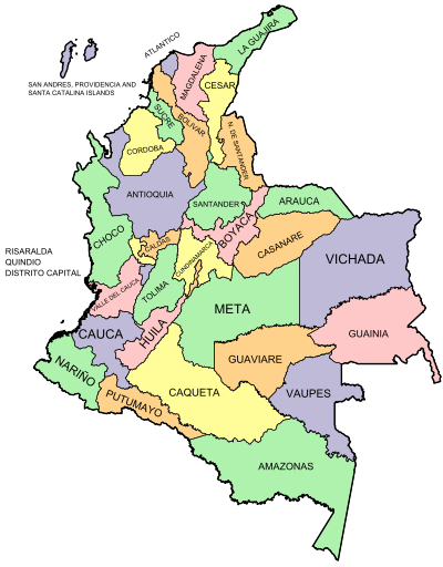
Administrative divisions
Colombia is divided into 32 departments and one capital district, which is treated as a department (Bogotá also serves as the capital of the department of Cundinamarca). Departments are subdivided into municipalities, each of which is assigned a municipal seat, and municipalities are in turn subdivided into corregimientos in rural areas and into comunas in urban areas. Each department has a local government with a governor and assembly directly elected to four-year terms, and each municipality is headed by a mayor and council. There is a popularly elected local administrative board in each of the corregimientos or comunas.[217][218][219][220]
In addition to the capital, four other cities have been designated districts (in effect special municipalities), on the basis of special distinguishing features. These are Barranquilla, Cartagena, Santa Marta and Buenaventura. Some departments have local administrative subdivisions, where towns have a large concentration of population and municipalities are near each other (for example, in Antioquia and Cundinamarca). Where departments have a low population (for example Amazonas, Vaupés and Vichada), special administrative divisions are employed, such as "department corregimientos", which are a hybrid of a municipality and a corregimiento.[217][218]
Click on a department on the map below to go to its article.

|

