A | B | C | D | E | F | G | H | CH | I | J | K | L | M | N | O | P | Q | R | S | T | U | V | W | X | Y | Z | 0 | 1 | 2 | 3 | 4 | 5 | 6 | 7 | 8 | 9
South India | |
|---|---|
 States and union territories in South India | |
| Country | |
| States and union territories | |
| Most populous cities | |
| Area | |
| • Total | 635,780 km2 (245,480 sq mi) |
| Highest elevation (Anamudi) | 2,695 m (8,842 ft) |
| Lowest elevation (Kuttanad) | −2.2 m (−7.2 ft) |
| Population (2011) | |
| • Total | 253,051,953 |
| • Density | 400/km2 (1,000/sq mi) |
| Demonym(s) | South Indian Telugu Tamilian Kannadiga Malayali Laccadivian Pondicherrian |
| Time zone | IST (UTC+5:30) |
| Official languages[1] | |
| HDI (2019) | |
| Literacy (2011) | 76.43%[2] |
| Sex ratio (2011) | 986 ♀/1000 ♂[3] |
South India, also known as Peninsular India, is the southern part of the Deccan Peninsula in India encompassing the states of Andhra Pradesh, Karnataka, Kerala, Tamil Nadu and Telangana as well as the union territories of Lakshadweep and Puducherry, occupying 19.31% of India's area (635,780 km2 or 245,480 sq mi) and 20% of India's population. It is bound by the Bay of Bengal in the east, the Arabian Sea in the west and the Indian Ocean in the south. The geography of the region is diverse, with two mountain ranges, the Western and Eastern Ghats, bordering the plateau heartland. The Godavari, Krishna, Kaveri, Tungabhadra and Vaigai rivers are important non-perennial sources of water. Chennai, Bangalore, Hyderabad, Coimbatore and Kochi are the largest urban areas in the region.
The majority of the people in South India speak at least one of the four major Dravidian languages: Telugu, Tamil, Kannada and Malayalam. During its history, a number of dynastic kingdoms ruled over parts of South India, and shaped the culture in those regions. Major dynasties that were established in South India include the Cheras, Cholas, Pandyas, Pallavas, Satavahanas, Chalukyas, Hoysalas, Rashtrakutas and Vijayanagara. European countries entered India through Kerala and the region was colonized by Britain, Portugal and France.
After experiencing fluctuations in the decades immediately after Indian independence, the economies of South Indian states have registered a sustained higher-than-national-average growth over the past three decades. South India has the largest combined largest gross domestic product compared to other regions in India. The South Indian states lead in some socio-economic metrics of India with a higher HDI as the economy has undergone growth at a faster rate than in most northern states. As of 2011, Literacy rates in the southern states is higher than the national average at approximately 76%. The fertility rate in South India is 1.9, the lowest of all regions in India.
Etymology
The name "South India" is combination of two English words: South indicating the cardinal direction and India from the name of the country literally meaning the Southern portion of India. It is also known as "Peninsular India" indicating its location in a peninsula surrounded by water on three sides.[4] The term "Deccan", referring to the area covered by the Deccan Plateau that covers most of peninsular India excluding the coastal areas, is an anglicised form of the Prakrit word dakkhiṇa derived from the Sanskrit word dakshiṇa meaning south.[5] Carnatic, derived from "Karnāḍ" or "Karunāḍ" meaning high country, has also been associated with South India.[6]
History
Ancient and Medieval era

Carbon dating shows that ash mounds associated with Neolithic cultures in South India date back to 8000 BCE. Towards the beginning of 1000 BCE, iron technology spread through the region; however, there does not appear to be a fully developed Bronze Age preceding the Iron Age in South India.[7] The region was in the middle of a trade route that extended from Muziris to Arikamedu linking the Mediterranean to East Asia.[8][9] Trade with Phoenicians, Romans, Greeks, Arabs, Syrians, Jews, and Chinese began during the Sangam period (c. 3rd century BCE to c. 4th century CE).[10] The region was part of the ancient Silk Road connecting the East with the West.[11]
Several dynasties such as the Cheras of Karuvur, the Pandyas of Madurai, the Cholas of Thanjavur, the Zamorins of Kozhikode, the Satavahanas of Amaravati, the Pallavas of Kanchi, the Kadambas of Banavasi, the Western Gangas of Kolar, the Rashtrakutas of Manyakheta, the Chalukyas of Badami, the Hoysalas of Belur, and the Kakatiyas of Orugallu ruled over the region from the 6th century BCE to the 14th century CE. In the 15th century, Vijayanagara empire was the last kingdom to conquer all of Southern India.[12] After repeated invasions from the Sultanate of Delhi, the Vijayanagara empire fell in 1646 and the region was ruled by various Deccan Sultanates, polygars and Nayak governors of the erstwhile Vijayanagara empire who declared independence.[13]
Colonial era
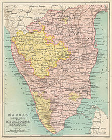
The Europeans arrived in the 15th century; and by the middle of the 18th century, the French and the British were involved in a protracted struggle for military control over South India. After the defeat of Tipu Sultan in the Fourth Anglo-Mysore War in 1799 and the end of the Vellore Mutiny in 1806, the British consolidated their power over much of present-day South India, with the exception of French Pondichéry. The British Empire took control of the region from the British East India Company in 1857.[14] During the British colonial rule, the region was divided into the Madras Presidency (later, the Madras Province), Hyderabad State, Mysore, and the Madras States Agency (composed of Travancore, Cochin, Jeypore, and a number of other minor princely states). The region played a major role in the Indian independence movement. Of the 72 delegates who participated in the first session of the Indian National Congress at Bombay in December 1885, 22 hailed from South India.[15]
Post-independence
After Indian Independence in 1947, the region was organized into four states Madras State, Mysore State, Hyderabad State and Travancore-Cochin.[16] Dravida Nadu was a proposal for a separate sovereign state for the speakers of the Dravidian languages in South India. Initially, the demand of Dravida Nadu proponents was limited to Tamil-speaking regions, but it was later expanded to include other Indian states with a majority of Dravidian-speakers in the region.[17] The States Reorganisation Act 1956, which created linguistic States, weakened the demand for a separate sovereign state.[18][19]
The States Reorganisation Act of 1956 reorganized the states based on linguistic lines resulting in the creation of the new states of Andhra Pradesh, Karnataka, Kerala and Tamil Nadu.[20][21] As a result of this act, Madras State retained its name with Kanyakumari district added to from Travancore-Cochin. The state was subsequently renamed Tamil Nadu in 1968.[22] Andhra Pradesh was created with the merger of Andhra State with the Telugu-speaking districts of Hyderabad State in 1956. Kerala was created with the merger of Malabar district and the Kasaragod taluk of South Canara districts of Madras State with Travancore-Cochin. Mysore State was re-organized with the addition of districts of Bellary and South Canara (excluding Kasaragod taluk) and the Kollegal taluk of Coimbatore district from the Madras State, the districts of Belgaum, Bijapur, North Canara and Dharwad from Bombay State, the Kannada-majority districts of Bidar, Raichur and Gulbarga from Hyderabad State and the province of Coorg.[23] Mysore State was renamed as Karnataka in 1973.[24] The Union Territory of Puducherry was created in 1954 comprising the previous French enclaves of Pondichéry, Karaikal, Yanam and Mahé.[20] The Laccadive Islands which were divided between South Canara and Malabar districts of Madras State were united and organized into the union territory of Lakshadweep.[20] Telangana was created on June 2, 2014, by bifurcating Andhra Pradesh and comprises ten districts in northwestern Andhra Pradesh.[25][26]
Geography
Topography
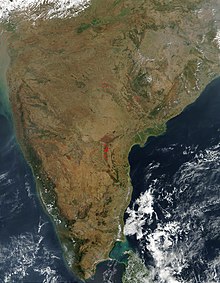
South India is a peninsula in the shape of an inverted triangle bound by Indian Ocean in the South, Arabian Sea in the west, by Bay of Bengal in the east and the Vindhya and Satpura ranges in the north.[27] The Narmada river flows westwards in the depression between the Vindhya and Satpura ranges, which define the northern spur of the Deccan plateau.[28] The low-lying coral islands of Lakshadweep are situated off the southwestern coast of India and the Andaman and Nicobar islands lie far off the eastern coast. The Palk Strait and the chain of low sandbars and islands known as Rama's Bridge separate the region from Sri Lanka, which lies off the southeastern coast.[29][30] The southernmost tip of mainland India is at Kanyakumari where the Indian Ocean meets the Bay of Bengal and the Arabian Sea.[31]
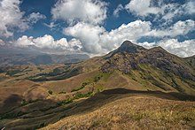
The Western Ghats runs south along the western coast from south of the Tapti River to Kanyakumari and forms a narrow strip of land with the Arabian sea called Konkan region.[32] Anai Mudi in the Anaimalai Hills 2,695 m (8,842 ft) is the highest peak in South India.[33] The Eastern Ghats run parallel to the Bay of Bengal along the eastern coast and the strip of land between them forms the Coromandel region.[34] They are a discontinuous range of mountains, which have been eroded and quadrisected by the four major rivers of southern India, the Godavari, Mahanadi, Krishna, and Kaveri.[35] Both mountain ranges meet at the Nilgiri mountains which run in a crescent approximately along the borders of Tamil Nadu with northern Kerala and Karnataka, encompassing the Palakkad and Wayanad hills and the Sathyamangalam ranges, extending to the relatively low-lying hills of the Eastern Ghats on the western portion of the Tamil Nadu–Andhra Pradesh border, forming the Tirupati and Annamalai hills.[36]
The Deccan plateau is the elevated region bound by the mountain ranges.[37] The plateau rises to 100 metres (330 ft) in the north and to more than 1 kilometre (0.62 mi) in the south, forming a raised triangle within the downward-pointing triangle of the Indian subcontinent's coastline.[38] It also slopes gently from West to East resulting in major rivers arising in the Western Ghats and flowing east into the Bay of Bengal.[39] The volcanic basalt beds of the Deccan were laid down in the massive Deccan Traps eruption, which occurred towards the end of the Cretaceous period, between 67 and 66 million years ago.[40] Layer after layer was formed by the volcanic activity that lasted many years and when the volcanoes became extinct, they left a region of highlands with typically vast stretches of flat areas on top like a table.[41] The plateau is watered by the east-flowing Godavari, Krishna, Kaveri and Vaigai rivers and their tributaries.[42]
Other prominent features include the Gulf of Mannar, the Palk Strait, which separates India from Sri Lanka; the Ten Degree Channel, which separates the Andamans from the Nicobar Islands; and the Eight Degree Channel, which separates the Laccadive and Amindivi Islands from the Minicoy Island to the south.[43] Laccadive Sea is a smaller sea.[44] There are coral reefs located in the Gulf of Mannar and Lakshadweep islands.[45] Large lakes include Vembanad Lake and Pulicat Lake.[46]
Climate


The region has a tropical climate and depends on monsoons for rainfall. According to the Köppen climate classification, it has a non-arid climate with minimum mean temperatures of 18 °C (64 °F).[47] The most humid is the tropical monsoon climate characterized by moderate to high year-round temperatures and seasonally heavy rainfall above 2,000 mm (79 in) per year. The tropical climate is experienced in a strip of south-western lowlands abutting the Malabar Coast, the Western Ghats and the Lakshadweep islands.[48]
A tropical wet and dry climate, drier than areas with a tropical monsoon climate, prevails over most of the inland peninsular region except for a semi-arid rain shadow east of the Western Ghats. Winter and early summer are long dry periods with temperatures averaging above 18 °C (64 °F); summer is exceedingly hot with temperatures in low-lying areas exceeding 50 °C (122 °F); and the rainy season lasts from June to September, with annual rainfall averaging between 750 and 1,500 mm (30 and 59 in) across the region. Once the dry northeast monsoon begins in September, most precipitation in India falls in Tamil Nadu, leaving other states comparatively dry.[49] A hot semi-arid climate predominates in the land east of the Western Ghats and the Cardamom Hills. The region – which includes Karnataka, inland Tamil Nadu and western Andhra Pradesh – gets between 400 and 750 millimetres (15.7 and 29.5 in) of rainfall annually, with hot summers and dry winters with temperatures around 20–24 °C (68–75 °F). The months between March and May are hot and dry, with mean monthly temperatures hovering around 32 °C (90 °F), with 320 millimetres (13 in) precipitation. Without artificial irrigation, this region is not suitable for agriculture.[50]
The southwest monsoon from June to September accounts for most of the rainfall in the region. The Arabian Sea branch of the southwest monsoon hits the Western Ghats along the coastal state of Kerala and moves northward along the Konkan coast, with precipitation on coastal areas west of the Western Ghats. The lofty Western Ghats prevent the winds from reaching the Deccan Plateau; hence, the leeward region (the region deprived of winds) receives very little rainfall.[51][52] The Bay of Bengal branch of the southwest monsoon heads toward northeast India, picking up moisture from the Bay of Bengal. The Coramandel coast does not receive much rainfall from the southwest monsoon, due to the shape of the land. Tamil Nadu and southeast Andhra Pradesh receive rains from the northeast monsoon.[53] The northeast monsoon takes place from November to early March, when the surface high-pressure system is strongest.[54] The North Indian Ocean tropical cyclones occur throughout the year in the Bay of Bengal and the Arabian Sea, bringing devastating winds and heavy rainfall.[55][56][57]

Flora and fauna
There is a wide diversity of plants and animals in South India, resulting from its varied climates and geography. Deciduous forests are found along the Western Ghats while tropical dry forests and scrub lands are common in the interior Deccan plateau. The southern Western Ghats have rain forests located at high altitudes called the South Western Ghats montane rain forests, and the Malabar Coast moist forests are found on the coastal plains.[58] The Western Ghats is one of the eight hottest biodiversity hotspots in the world and a UNESCO World Heritage Site.[59][60]
Important ecological regions of South India are the Nilgiri Biosphere Reserve in the Nilgiri Hills, the Agasthyamala Biosphere Reserve in the Agastya Mala-Cardamom Hills and Gulf of Mannar coral reefs.[61] The Gulf of Mannar Biosphere Reserve covers an area of 10,500 km2 (4,100 sq mi) of ocean, islands and the adjoining coastline including coral reefs, salt marshes and mangroves. It is home to endangered aquatic species, including dolphins, dugongs, whales and sea cucumbers.[62][63] Bird sanctuaries including Thattekad, Kadalundi, Vedanthangal, Ranganathittu, Kumarakom, Neelapattu, and Pulicat are home to numerous migratory and local birds.[64][65]
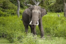
South India is home to one of the largest populations of endangered Bengal tigers and Indian elephants in India, being home to one-third of the tiger population and more than half of the elephant population,[66][67] with 14 Project Tiger reserves and 11 Project Elephant reserves.[68][69] Elephant populations are found in eight fragmented sites in the region: in northern Karnataka, along the Western Ghats, in Bhadra–Malnad, in Brahmagiri–Nilgiris–Eastern Ghats, in Nilambur–Silent Valley–Coimbatore, in Anamalai–Parambikulam, in Periyar–Srivilliputhur, and in Agasthyamalai[70] Other threatened and endangered species found in the region include the grizzled giant squirrel,[71] grey slender loris,[72] sloth bear,[73] Nilgiri tahr,[74] Nilgiri langur,[75] lion-tailed macaque,[76] and the Indian leopard.[77]
| Name | Animal | Bird | Tree | Fruit | Flower |
|---|---|---|---|---|---|
| Andhra Pradesh[79] | Blackbuck (Antilope cervicapra) | Rose-ringed parakeet (Psittacula krameri) | Neem (Azadirachta indica) | Mango (Mangifera indica) | Common jasmine (Jasminum officinale) |
| Karnataka[80] | Indian elephant (Elephas maximus) | Indian roller (Coracias indica) | Sandalwood (Santalum album) | Mango (Mangifera indica) | Lotus (Nelumbo nucifera) |
| Kerala[81] | Indian elephant (Elephas maximus) | Great hornbill (Buceros bicornis) | Coconut (Cocos nucifera) | Jackfruit (Artocarpus heterophyllus) | Cana fistula (Cassia fistula) |
| Lakshadweep[82] | Butterfly fish (Chaetodon falcula) | Noddy tern (Anous stolidus) | Bread fruit (Artocarpus incisa) | ||
| Puducherry[83] | Indian palm squirrel (Funambulus palmarum) | Koel (Eudynamys scolopaceus) | Bael fruit (Aegle marmelos) | Cannonball (Couroupita guianensis) | |
| Tamil Nadu[84] | Nilgiri tahr (Nilgiritragus hylocrius) | Emerald dove (Chalcophaps indica) | Palmyra palm (Borassus flabellifer) | Jackfruit (Artocarpus heterophyllus) | Glory lily (Gloriosa superba) |
| Telangana[85] | Chital deer (Axis axis) | Indian roller (Coracias indica) | Khejri (Prosopis cineraria) | Mango (Mangifera indica) | Tanner's cassia (Senna auriculata) |
Politics
Politics in South India is characterized by a mix of regional and national political parties. The Justice Party and Swaraj Party were the two major parties in the erstwhile Madras Presidency.[86] The Justice Party eventually lost the 1937 elections to the Indian National Congress, and Chakravarti Rajagopalachari became the Chief Minister of the Madras Presidency.[86] During the 1920s and 1930s, the Self-Respect Movement, spearheaded by Theagaroya Chetty and E. V. Ramaswamy (commonly known as Periyar), emerged in the Madras Presidency.[87] In 1944, Periyar transformed the party into a social organisation, renaming the party Dravidar Kazhagam, and withdrew from electoral politics. The initial aim was the secession of Dravida Nadu from the rest of India upon Indian independence. After independence, C. N. Annadurai, a follower of Periyar, formed the Dravida Munnetra Kazhagam (DMK) in 1948. The Anti-Hindi agitations of Tamil Nadu led to the rise of Dravidian parties that formed Tamil Nadu's first government, in 1967. In 1972, a split in the DMK resulted in the formation of the All India Anna Dravida Munnetra Kazhagam (AIADMK) led by M. G. Ramachandran. Dravidian parties continue to dominate Tamil Nadu electoral politics, the national parties usually aligning as junior partners to the major Dravidian parties, AIADMK and DMK.[88][89]
Indian National Congress dominated the political scene in Tamil Nadu in the 1950s and 1960s under the leadership of K. Kamaraj, who led the party after the death of Jawaharlal Nehru and ensured the selection of Prime Ministers Lal Bahadur Shastri and Indira Gandhi.[90] Congress continues to be a major party in Telangana, Karnataka, and Kerala. The party ruled with minimal opposition for 30 years in Andhra Pradesh, before the formation of the Telugu Desam Party by Nandamuri Taraka Rama Rao in 1982.[91] Two prominent coalitions in Kerala are the United Democratic Front, led by the Indian National Congress, and the Left Democratic Front, led by the Communist Party of India (Marxist). For the past fifty years, these two coalitions have been alternately in power; and E. M. S. Namboodiripad, the first elected chief minister of Kerala in 1957, is credited as the leader of the first democratically elected communist government in the world.[92][93] The Bharatiya Janata Party and Janata Dal (Secular) are significant parties in Karnataka.[94]
C. Rajagopalachari, the first Indian Governor General of India post independence, was from South India. The region has produced six Indian presidents, namely, Sarvepalli Radhakrishnan,[95] V. V. Giri,[96] Neelam Sanjiva Reddy,[97] R. Venkataraman,[98] K. R. Narayanan,[99] and APJ Abdul Kalam.[100] Prime ministers P. V. Narasimha Rao and H. D. Deve Gowda were from the region.[101]
Administration
South India consists of the five southern Indian states of Andhra Pradesh, Telangana, Karnataka, Kerala, and Tamil Nadu, as well as the union territories of Puducherry, and Lakshadweep.[102] Puducherry and the five states each have an elected state government, while Lakshadweep is centrally administered by the president of India.[103]
Each state is headed by a Governor who is appointed by the President of India and who names the leader of the state legislature's ruling party or coalition as chief minister, who is the head of the state government.[104][105]
Each state or territory is further divided into districts, which are further subdivided into revenue divisions and taluks / Mandals or tehsils.[106] Local bodies govern respective cities, towns, and villages, along with an elected mayor, municipal chairman, or panchayat chairman, respectively.[107]
States
| Name | ISO[108][109] | Estd.[23] | Population[110][111] | Area (km2)[112] |
Official language(s)[113] |
Capital | Population density (per km2)[112] |
Sex Ratio[112] | Literacy(%)[114] | % urban pop.[115] |
|---|---|---|---|---|---|---|---|---|---|---|
| Andhra Pradesh | AP | 1 Oct 1953 | 49,506,799 | 162,968 | Telugu, English | Amaravati | 308 | 996 | 67.41 | 29.4 |
| Karnataka | KA | 1 Nov 1956 | 61,095,297 | 191,791 | Kannada, English | Bengaluru | 319 | 973 | 75.60 | 38.67 |
| Kerala | KL | 1 Nov 1956 | 33,406,061 | 38,863 | Malayalam, English | Thiruvananthapuram | 860 | 1084 | 94.00 | 47.72 |
| Tamil Nadu | TN | 26 Jan 1950 | 72,147,030 | 130,058 | Tamil, English | Chennai | 555 | 996 | 80.33 | 48.40 |
| Telangana | TG | 2 Jun 2014 | 35,193,978 | 112,077 | Telugu, Urdu | Hyderabad | 307 | 988 | 66.50 | 38.7 |
- ^Note 1 Andhra Pradesh was divided into two states, Telangana and a residual Andhra Pradesh on 2 June 2014.[116][117] Hyderabad, located entirely within the borders of Telangana, is to serve as joint capital for both states for a period of time not exceeding ten years.[118]
Union territories
| Name | ISO[108][109] | Estd.[23] | Population | Area (km2)[112] |
Official language[113] |
Capital | Population density (per km2)[112] |
Sex Ratio[112] | Literacy (%)[114] | % urban pop.[115] |
|---|---|---|---|---|---|---|---|---|---|---|
| Lakshadweep | LD | 1 Nov 1956 | 64,473 | 30 | English, Malayalam | Kavaratti | 2,013 | 946 | 92.28 | 78.07 |
| Puducherry | PY | Zdroj:https://en.wikipedia.org?pojem=South_Indian


